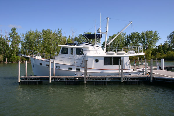
Cruising Tips and Tricks
- stevelewis21
- Apr 7
- 8 min read
Over the past 8 years my wife and I have been cruising around the Great Lakes on our boat. We have learned a few things along the way. I figured sharing that knowledge might be useful for those who might want to start stretching their legs and cruising to destinations both close by and far away.
We start with planning. Where would you like to go? There are quite a few places to go visit and experience the fun things that are on offer. Places as close as Sandusky and as far away as Chicago! The research that goes into your choice of destination can be just as fun as getting there. A few of the resources that we have used are listed below:
1. Lakeland Boating magazine has the “Ports of Call” section
2. Tourism sites for the states that are on the Great Lakes
3. Stories from other boaters
a. Like Mark our Dock Master
Once you choose a destination, you need to plan your cruise to get there and back. This is where the fun can really begin as you choose your daily stops, the navigation to get you there each day, food planning(provisioning), fueling considerations and of course weather. This summer we are planning to go back to Mackinaw/Machinac. Yes it is spelled two different ways based on English and French. The Island is a great destination whether you stay on the island or, as we will be doing, in Mackinaw City and taking the ferry over to the Island. Let’s use this trip as an example of how to plan for a cruise.
Now that we have a destination, I tend to start with Navigation and daily stops. We are a slow moving Trawler so our daily distances are limited by how long we can go before we need to stop and let our dog Rudy get off and, well…. You know. Our daily limit is about 10hours. We have done the trip before so we are acquainted with the marinas and reciprocating Yacht Clubs that are available along the way. When heading North into Lake Huron you do need to take into account the south bound current on the Detroit and St. Clair rivers. I learned that “The Hard Way” on our first trip north. It is around 3mph so plan on your speed decreasing by 3mph as you head north on the rivers. For us previously on our Sea Ray Sundancers that meant cruising on plane on Lake Erie at about 24mph until we reached the rivers and then speed decreases to 21mph. It is a little disconcerting the first time you encounter the current. Your engine RPM and fuel burn do not change but the boat just slows down against the current. Make sure you plan for that with your fueling for that leg of the trip. Our digital fuel gauge was blinking at us that we were getting very low on fuel on the first day of our first north bound trip. The following are our planned daily destinations:
1. Detroit Yacht Club
2. Port Huron Yacht Club
3. Harbor Beach
4. Tawas
5. Presque Isle
6. Detour Village
7. Mackinaw City (Straights State Marina)
When planning these daily stops, I used the Marineways.com website to plot each day’s route and get distances and then calculate time based on our normal cruise speed. There are plenty of other methods for plotting the route including using your navigation electronics(Garmin or Raymarine GPS etc..). I find that using the online tool makes it easier to try different routes and destination options. This also helps you plan for fuel as you make your trip. We have found that there are plenty of marinas along the way to top off or take on a splash of fuel. Algonac is a convenient stop part way up the rivers if you need to take on fuel on the rivers. Once you are at the north end of the St. Clair river you have stops along the coast of Michigan every 25 miles or so. Lexington, Port Sanilac, Harbor Beach, Tawas, Alpena, Presque Isle, Rogers City, Cheboygan and Mackinaw. There are others in there but you get the idea. You are never too far from a marina that has fuel and is also a refuge from weather.
Speaking of Weather! That is a very important topic. You will ALWAYS encounter weather on a trip that is of this length. We ALWAYS plan a couple of extra days for “Staying Put” to wait out the weather. We have hunkered down in Erie PA, Alpena and Tawas to let the weather blow through. We even tucked into Rogers City to let a Thunderstorm pass by to the North. We took the time to let Rudy off the boat and take on fuel. They were nice enough to let us stick around for 2 hours after we took on fuel to let the weather pass. People in these marinas are really nice. It is a common experience we have had along the way so another tip is to take a little extra cash and beer as currency for things that you may find that you need along the way. We bought a bilge pump from a couple in Tawas for cash and 6 assorted beers.
We use weather.com, windy.com and nws marine.weather.gov for looking at weather forecasts and wind and wave forecasts. We find they are accurate-ish starting 2 days before you really need to understand what the weather will be. So on Thursday I can trust the forecast for Saturday……. Let me know what systems you use for looking at weather.
Meals and Menu. We tend to make our own meals as opposed to eating out as this saves a ton of money and you can eat healthier by making your own food. We plan our meals a week ahead of the trip, go shopping then cook the main part of the meal, portion it out and freeze it. As an example, we would cook a pork loin then slice it, place 3-4 pieces in Ziplock bags and freeze them. Each pork loin made 4 portions so 2 dinner meals for each of us. We also buy the frozen microwave vegetables and Riced Cauliflower(I have some food tolerance issues). This all goes in the freezer and we can choose what we want to eat each morning and then move what we want to the fridge to start thawing. We also carry fresh food as we have good cooking facilities on the trawler. Another tip is that most of the Marinas have gas grills for use when you spend the night just like we do at MBIYC. That is also a handy way to cook and can be a social event when others are cooking as well. There are grocery stores along the way that will allow you to provision. Tawas has a Walmart that is within walking distance as well as some autopart stores that carry some limited marine stuff. Rogers City and Mackinaw City have good grocery stores within walking distance. That can help if you are not able to carry all of your food onboard. Sheplers Marine in Mackinaw City is very good marine parts store and marine service center with mechanics if you need them. We did one time to diagnose an issue. Nothing big but it was inconvenient to have an issue with the starting circuit on our port Cummins diesel. Ask me about that sometime at the Yacht Club and we will tell you a fun story over a beverage!
If you like to eat out, check each daily destination for restaurants and their hours of operation. Lexington MI has the Windjammer right there by the marina. Their sushi is fantastic, if you like sushi. Presque Isle MI has a surprisingly good general store right there by the marina. I say that because it is in the middle of no where………
Reservations…….. There are multiple systems that you will be interacting with based on which one each marina uses. DockWa is a popular system that has an APP for your mobile device and Michigan has a website, https://midnrreservations.com/ , that allows you to reserve a slip up to 6months ahead of time. There some different schools of thought on making reservations. I want a reservation at marinas when cruising far afield. It is a personal choice but I want them so that I am confident that we have a place to tie up at the end of each day. Be aware of local events and Holiday traffic as sometimes there are no slips to be had. I do a little research online to see if there is an event. As an example, we took a trip a few years ago and it coincided with the Chicago to Mackinac Island sailboat race. We were able to get a slip at Straights State Marina but it would have been impossible to get one at Mackinac Island Marina. I tend to book the first half of the trip before we start and then hop online as we make our way along and reserve slips for the way back while heading North. That has worked out well for us. Same thing heading East to Buffalo. We were able to get spots along the way without issue.
Navigation Rules. This is an interesting one. When you start to cruise distances it is really good to know the Rules of the Road. 33 CFR 88.05 states that ALL vessels 12meters in length and longer MUST carry a copy of the Navigation Rules found here.
When on the Rivers it is important to understand the Rules since commercial freighter traffic is present and the downbound current presents specific rule conventions that should be understood. There are 38 of them but mostly understanding the first 19 of them will serve you well in my opinion. Another interesting thing to know is that there is a service named Vessel Traffic Services or VTS that is in operation in various areas. The Rivers are an important one. VTS is like Air Traffic Control for planes. Commercial vessels are required to check in with VTS at designated points along the way. VTS will space the freighters and otherwise manage the commercial traffic. The check in points are marked on the nav charts. You can listen to that communication on channels 11 and 12. 12 is in use south of the middle point of Lake St. Clair and 11 is in use north of that point. As an example, we were following the Paul R. Tregurtha south bound on the St Clair river 2 years ago. We were able to listen to the VTS coms while forming up in the line of Freighters about to head south on the rivers coming off of Lake Huron. When we got to the DTE power plant in St Clair MI the freighter CSL St. Laurent was north bound and approaching the Paul R Tregurtha. The captain of the Tregurtha hailed the captain of the CSL St Laurent on VHF 11 and instructed him to “Pass on my 2 as I am already starting my turn”. Which meant the north bound freighter was going to pass between the Tregurtha and the west shore of the river which is passing starboard to starboard which is the opposite of the normal convention. The Tregurtha had “Right of Way” as he was initially headed southbound with a following current. That is one of the nuances of the Rules. We hailed the Tregurtha and asked permission to pass behind him southbound on his 1 as he was turning his 1000+ foot freighter around in the middle of the river. We knew the rules, we knew how to communicate and what our responsibility was when in close proximity to the freighters. The captain of the Tregurtha replied and allowed us to pass. They waived at us as we went by. We felt very small and insignificant next to that freighter.
Please feel free to come by the Kadey Krogen "Just Us II" when you see us and ask anything. We will oblige with stories and beverages.
Over and Out. Back to monitoring 9, 11, 12 and 16.
Comments